Antique maps offer a glimpse into the past, serving as historical records and artistic masterpieces. Collectors and historians alike cherish these artifacts for their intricate designs, historical accuracy, and unique charm. Authentic antique maps not only provide geographical insights but also reflect the cartographic knowledge and artistic styles of different eras. This article explores the significance of antique maps, how to authenticate them, and their enduring value in today’s world.
The History and Evolution of Antique Maps
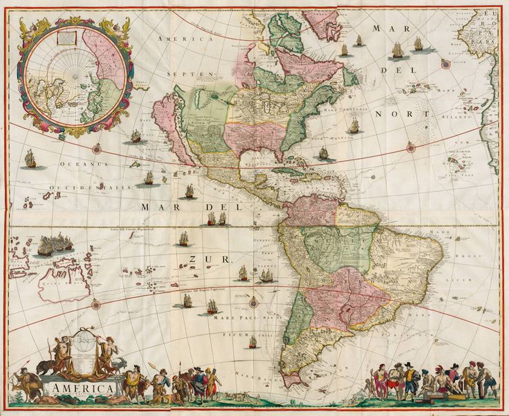
The history of cartography dates back to ancient civilizations, with early maps appearing on clay tablets, parchment, and paper. The medieval period saw maps that were often symbolic, focusing on religious and mythological depictions rather than precise geography. The Age of Exploration in the 15th and 16th centuries brought significant advancements in mapmaking, with explorers like Christopher Columbus and Vasco da Gama relying on navigational charts. The 17th and 18th centuries marked the golden age of cartography, with renowned mapmakers such as Gerardus Mercator, Willem Blaeu, and John Speed producing highly detailed and decorative maps. The 19th century saw the transition from hand-drawn maps to lithographic prints, making maps more widely available.
Characteristics of Authentic Antique Maps
Authentic antique maps exhibit distinct characteristics that set them apart from modern reproductions. One of the primary features is the type of paper used. Early maps were printed on handmade rag paper, which has a unique texture and durability. Later maps were created using wood pulp paper, which can show signs of aging. The printing technique is another indicator of authenticity. Early maps were printed using woodblock, copperplate, or lithographic methods, each leaving distinct impressions on the paper. The coloration of antique maps also provides clues to their authenticity. Hand-colored maps were common in the 16th to 19th centuries, with pigments carefully applied to enhance decorative elements. Signs of aging, such as foxing, patina, and watermarks, further confirm a map’s authenticity.
How to Authenticate an Antique Map
Authenticating an antique map requires a keen eye and knowledge of historical cartography. The first step is to examine the paper quality and texture, as genuine antique maps have a distinct feel that differs from modern reproductions. The printing method should be analyzed under magnification to determine whether it matches historical techniques. Watermarks, often found on authentic antique maps, can help date the paper and confirm its legitimacy. Provenance, or the history of ownership, is another crucial factor. Maps with a well-documented history and verifiable sources are more likely to be authentic. Comparing the map to reference catalogs and museum collections can also aid in authentication.
The Value of Antique Maps
The value of an antique map depends on several factors, including rarity, historical significance, condition, and cartographer. Maps produced by famous cartographers like Ortelius, Mercator, and Blaeu are highly sought after and command high prices. Rare maps depicting early explorations, colonial territories, or extinct geographical features are particularly valuable. The condition of the map, including the presence of tears, stains, or missing sections, can significantly impact its worth. Maps with original hand-coloring and minimal restoration tend to retain higher value. Historical context also plays a role, as maps that document significant events or political changes are highly desirable among collectors.
Famous Antique Mapmakers
Several renowned cartographers have left a lasting legacy in the world of antique maps. Gerardus Mercator, a 16th-century Flemish cartographer, is best known for the Mercator projection, which revolutionized navigation. Abraham Ortelius, the creator of the first modern atlas, produced highly detailed and decorative maps that remain valuable today. Willem Blaeu, a Dutch cartographer from the 17th century, was known for his beautifully crafted maps that set the standard for cartographic excellence. John Speed, an English mapmaker, produced some of the most detailed and visually striking maps of Great Britain and the world. Each of these cartographers contributed to the advancement of mapmaking and left behind a legacy of exquisite maps that are highly prized by collectors.
The Artistry of Antique Maps
Beyond their historical significance, antique maps are admired for their artistic qualities. Many antique maps feature elaborate cartouches, which are decorative frames containing the title and other details. These embellishments often include allegorical figures, mythological creatures, and intricate floral designs. Some maps also depict sea monsters and ships, reflecting the adventurous spirit of early explorers. The hand-coloring of antique maps adds to their visual appeal, with colors carefully applied to distinguish different regions and highlight important features. The combination of artistry and cartographic precision makes antique maps both valuable historical documents and stunning works of art.
Collecting Antique Maps
For those interested in collecting antique maps, there are several factors to consider. Beginners should start by researching different types of maps and their historical contexts. Understanding the differences between original maps and reproductions is essential to making informed purchases. Establishing a relationship with reputable dealers and auction houses can help collectors find authentic pieces. Proper storage and preservation are also crucial in maintaining the condition of antique maps. Maps should be kept in sleeves, away from direct sunlight and humidity, to prevent deterioration. Framing maps with UV-protective glass can also help preserve their colors and integrity.
Where to Find Authentic Antique Maps
Authentic antique maps can be found in various places, including auction houses, antique shops, specialized map dealers, and online marketplaces. Reputable auction houses like Sotheby’s and Christie’s often feature rare and valuable maps in their sales. Specialized dealers with expertise in antique maps can provide valuable insights and authentication services. Online platforms such as eBay and dedicated antique map websites offer a wide selection, but buyers should exercise caution and verify the credibility of the sellers. Visiting map fairs and exhibitions is another great way to explore different maps and network with experts and fellow collectors.
The Future of Antique Maps
Despite the digital age and the prevalence of modern mapping technology, antique maps continue to hold their appeal. The uniqueness and historical value of these maps make them cherished collectibles. Museums and institutions are increasingly digitizing antique maps to make them accessible to a wider audience while preserving their physical copies. The growing interest in historical artifacts and the resurgence of vintage aesthetics have also contributed to the enduring popularity of antique maps. As more collectors and enthusiasts appreciate the significance of these cartographic treasures, the market for authentic antique maps is likely to remain strong.
Conclusion
Authentic antique maps are more than just geographical representations; they are windows into history, art, and exploration. Their intricate details, historical significance, and aesthetic appeal make them highly valued by collectors and historians. Understanding how to authenticate and preserve antique maps is essential for anyone interested in this fascinating field. Whether for investment, decoration, or historical research, antique maps continue to captivate and inspire, preserving the legacy of centuries-old cartographic mastery.